Infrastructure assessment is becoming a bottleneck.
Active travel schemes increasingly require structured evidence, consistent scoring and transparent review. But many teams still rely on manual analysis, spreadsheets, fragmented GIS layers and repeated engineering judgement. This makes assessment slow, difficult to standardise and hard to scale across multiple routes, city areas or option comparisons.
Too much assessment work is still assembled by hand.
The result is slower review, harder comparison and less confidence when decisions need to be explained to funders, members, stakeholders and delivery teams.
Manual workflows
Route checks and evidence gathering are still heavily spreadsheet-based.
Fragmented evidence
Imagery, GIS layers, comments and scoring often sit in separate places.
No network picture
Cities struggle to see safety, comfort and cohesion issues across whole active travel networks.
Hard investment choices
Without consistent evidence, prioritising routes, costs and interventions is difficult to defend.
Time
Manual assessment effort slows down route and corridor review.
Evidence
Decisions are harder to defend when scores and assumptions are separated.
Scale
Whole-network safety, comfort and cohesion issues are difficult to compare.
Assess, map and compare active travel infrastructure.
StreetVision is building the infrastructure intelligence layer for active travel networks. It brings route checks, city assessment mapping, evidence review and network option analysis into one workflow, so decisions stay connected to the data, imagery, scores and assumptions behind them.
Assess detailed corridors
Map city-wide issues
Prioritise investment
Route and corridor assessment
Draw routes, split segments, collect evidence and review ATE-aligned or locally configured metrics.
Connected review evidence
Keep imagery, mapped data, notes, scoring logic, comments, overrides and confidence states together.
City assessment mapping
Assess routes, corridors or whole city areas for safety, comfort, access and cohesion issues.
Cost-aware optioneering
Compare route options by safety, comfort, demand, estimated cost, utility and confidence before export.
One workflow from route definition to export.
Designed to reduce repeated desktop assessment effort while preserving professional judgement.
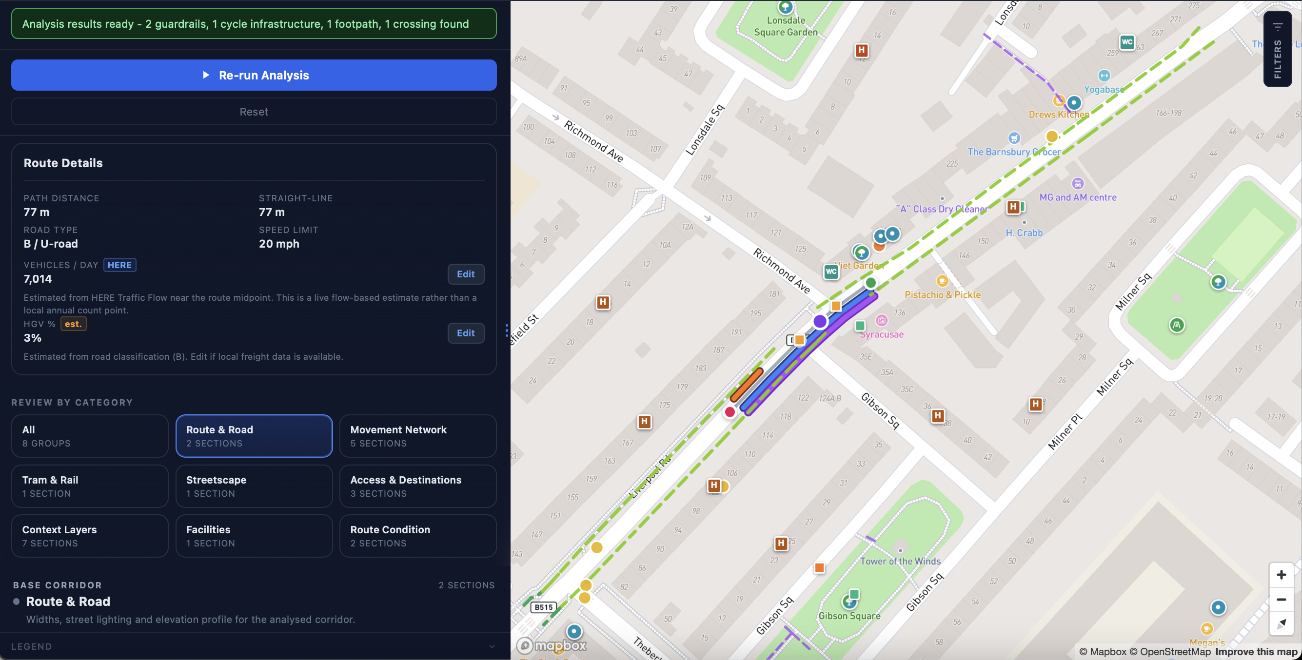
Set the route check, corridor, scheme or network area.
Draw routes, split segments and manage options.
Pull together mapped context, street-level imagery and reviewer notes.
Work through ATE-aligned or locally configured assessment criteria.
Compare route options, weak links, estimated costs, utility and confidence.
Produce auditable summaries, reports and spreadsheet-ready outputs.
ATE Route Checks without spreadsheet chaos.
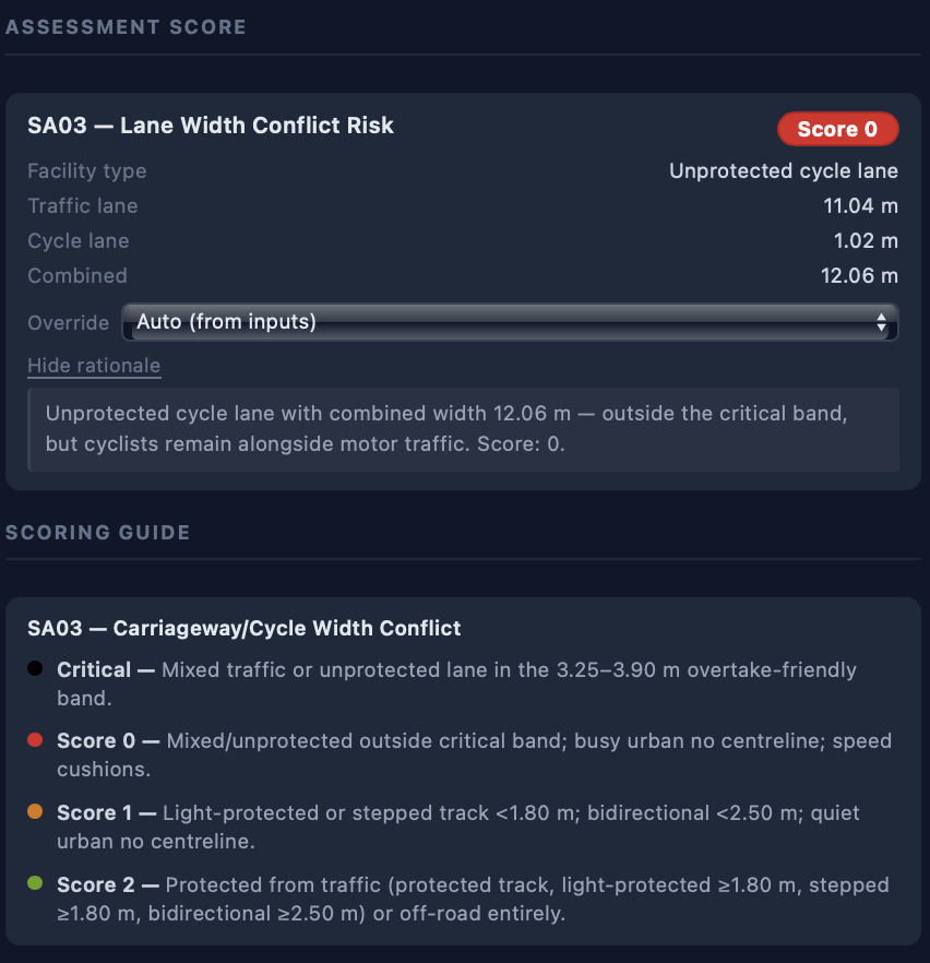
Active Travel England Route Checks are a structured assessment process for walking and cycling schemes in England. StreetVision digitises the workflow around route segmentation, metric review, evidence collection, comments, overrides, confidence and exportable outputs.
CV-assisted checks support engineering review.
Scores, comments, overrides and confidence remain visible so teams can defend the assessment rather than treat it as a black-box output.
Designed for engineering review
StreetVision supports assessment. It does not remove professional judgement. Engineers can review, override and evidence every score.
Pre-populated metrics
Use mapped and visual signals to reduce repetitive manual review.
Evidence-linked scoring
Keep comments, imagery, assumptions and scoring connected.
Export-ready outputs
Produce review-ready summaries and ATE-compatible assessment outputs.
Map whole networks, then compare what to build next.
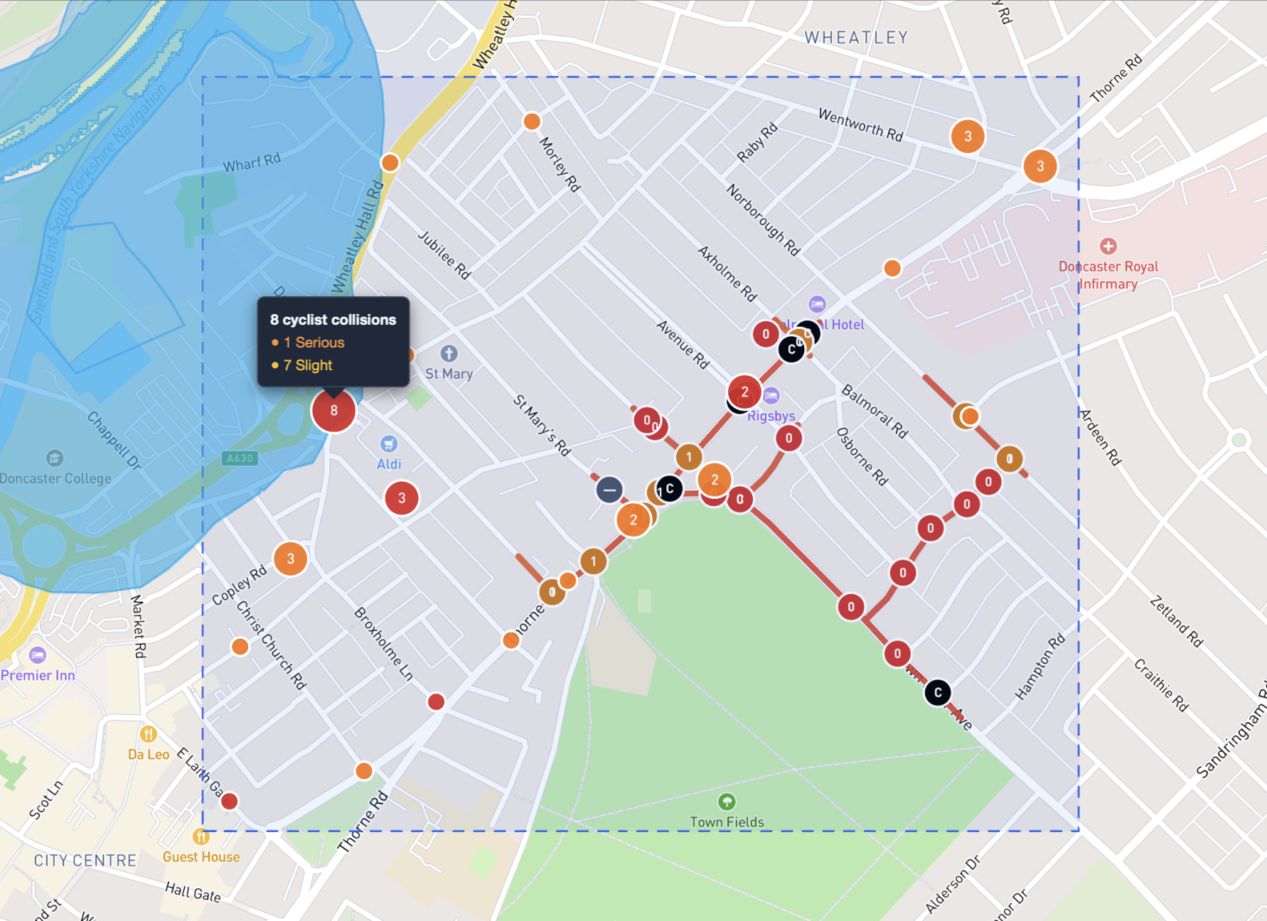
StreetVision helps cities move beyond one-off route reviews. Assessment maps can show where walking, wheeling and cycling infrastructure is unsafe, uncomfortable, disconnected or inconsistent across corridors, neighbourhoods and whole network areas.
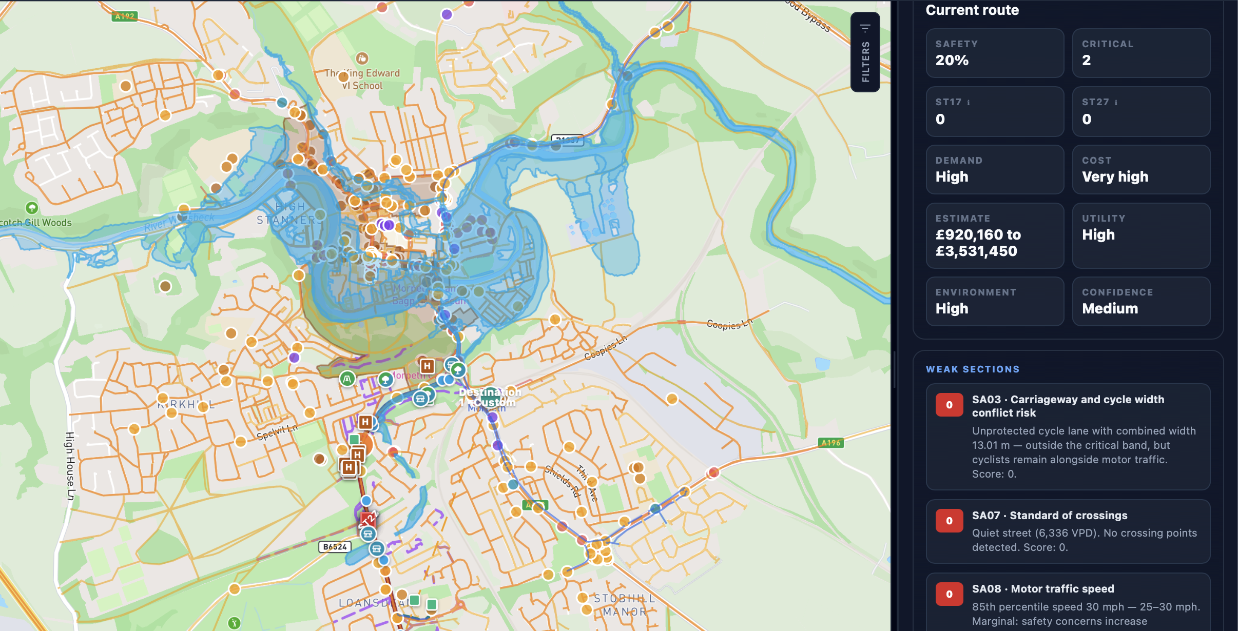
Network analysis then supports decision-making: compare route options, weak links, likely interventions, estimated costs, safety, utility, demand and confidence before prioritising investment.
Route evidence becomes a reusable city-wide infrastructure intelligence layer.
City assessment map
Build a mapped view of active travel infrastructure quality across routes, corridors or whole network areas.
Safety and comfort issues
Identify where walking, wheeling and cycling conditions are unsafe, uncomfortable or inconsistent.
Network cohesion
Understand where routes connect well, where links break down and where barriers reduce active travel uptake.
Option analysis
Compare potential route options, interventions and corridors before committing engineering effort.
Cost and utility estimates
Bring estimated costs, demand, safety, utility and confidence into the same decision view.
Investment priority areas
Target funding where infrastructure improvements can create cleaner, healthier and more active places.
Safety risk mapping
Show where users face higher-risk crossings, junctions, gaps or uncomfortable conditions.
Comfort and access scoring
Track whether walking, wheeling and cycling infrastructure is attractive enough for everyday trips.
Cohesive network planning
Find missing links and corridor issues that stop routes working as a connected network.
Defensible investment
Prioritise interventions with a visible evidence trail, not isolated opinion or static maps.
Designed to reduce assessment effort and improve confidence.
Current StreetVision assessment workflows save engineers 80-95% of assessment time while making route, network and investment decisions easier to evidence, compare and defend.
engineering assessment time saved
Current StreetVision assessment workflows materially reduce repetitive desktop review.
network-wide issues visible
Safety, comfort, access and cohesion issues can be reviewed across places.
investment decisions supported
Route options can be compared with estimated cost, utility and confidence.
Faster review
Current assessment workflows save engineers 80-95% of assessment time compared with manual desktop review.
More consistent scoring
Use structured workflows and shared scoring logic across teams.
Cost-aware decisions
Compare route options with estimated cost, demand, utility, safety and confidence in view.
Scalable network insight
Move from individual route checks to city-wide network assessment and investment planning.
Built for the organisations shaping active travel networks.
StreetVision is designed around the practical detail of ATE Route Checks, then extends the same evidence-led workflow to corridors, cities and operating areas. That helps investment reach the places where better walking, wheeling and cycling facilities can have the greatest impact.
Local authorities
Assess schemes, map network issues and prepare evidence-backed reviews that help improve walking, wheeling and cycling facilities.
Engineering consultancies
Standardise route checks, reduce repetitive desktop work and deliver clearer outputs for clients.
Transport agencies
Review infrastructure quality across corridors, schemes and network areas, then compare intervention options.
European cities
Benchmark cycling and walking networks so investment can support cleaner, healthier and more active cities.
Micromobility operators
Understand infrastructure conditions across operating areas and support policy, tender and safety conversations.
Insurers and risk teams
Use infrastructure context to support area-level risk narratives and network comparisons.
Developed with real infrastructure workflows in mind.
StreetVision has been shaped through conversations with active travel engineers, public-sector transport teams, local authorities, infrastructure consultants and geospatial ecosystem partners.
Active travel domain expertise
Built with direct understanding of route checks and engineering assessment workflows.
Public-sector workflow focus
Designed around auditability, review states, evidence and controlled project visibility.
Geospatial ecosystem
Part of a Geospatial ecosystem, with a roadmap for deeper geospatial data integration.
Pilot conversions
Engaging with authorities, consultancies and city stakeholders around live assessment and network use cases.
Pilot StreetVision on a live corridor or network area.
A typical pilot is designed to validate the workflow against a real route check, corridor study, network planning area or option comparison.
By the end of the pilot, the organisation should understand whether StreetVision can reduce manual assessment effort, improve consistency, map infrastructure issues and support evidence-backed investment decisions.
Kick-off and data scoping
Area selection
Local dataset configuration
Route assessment workflow
Evidence and metric review
Network option analysis
Estimated cost and utility review
Exportable outputs
Feedback and pilot review session
Best fit for
Practical controls for public-sector and consultancy workflows.
StreetVision is being designed around the realities of public-sector review, collaborative project teams and data handling conversations.
Role-based access
Controlled permissions for project teams, reviewers and collaborators.
Audit trails
Review states, comments, overrides and export history designed for traceability.
Project visibility
Workspace controls for live corridors, network areas and pilot scopes.
Evidence provenance
Keep scores, comments, imagery, assumptions and reviewer actions connected.
Data handling
Designed to support DPIA, procurement and data governance conversations as the platform scales.
Compliance roadmap
Security, documentation and assurance controls developed alongside pilot and deployment requirements.
Why StreetVision matters.
Active travel infrastructure is becoming a measurable asset class. Cities need better ways to understand where networks are safe, comfortable, connected and investment-ready, so they can improve cycling and walking facilities and encourage more active travel. StreetVision creates the structured assessment layer needed to make infrastructure quality visible, comparable and actionable.
Focused assessment workflow
Start with route checks, corridor studies and engineering review workflows.
Data advantage
Build structured evidence on infrastructure quality.
Network expansion
Scale from routes to whole-city active travel network intelligence.
Multi-market relevance
Serve authorities, consultancies, operators, insurers and European cities.
Book a pilot walkthrough with a live corridor in mind.
Share the route check, city network area, option analysis or assessment workflow you want to validate. We will respond with a practical pilot scope and product walkthrough.